Architecture / Street / Videography
Architecture / Street / Videography
Budapest From Above in 4K: Architecture, Aerial Geometry, and the Drone Pilot’s Challenge (90 Minutes)
Budapest is a city that competes with itself for the best aerial frames. It is not a single skyline—it’s a layered urban composition where river, bridges, monumental civic architecture, and hillside heritage districts constantly try to steal the shot from each other. From a drone’s perspective, it’s one of Europe’s most “photogenic-by-design” cities: the Danube acts like a leading line through the entire composition, while both banks deliver architectural icons at near-perfect spacing.
This 90-minute 4K drone film documents Budapest as an aerial subject: how the city reads from above, what architecture dominates at altitude, and what makes it challenging to film—not in theory, but in practice.
Why Budapest Works So Well From the Air: The City Is Built Like a Shot List
Budapest’s aerial power comes from the way its landmarks form a continuous, readable sequence along the river. UNESCO describes the area as an “outstanding urban landscape,” and that’s exactly what a drone camera sees: a city designed for long, uninterrupted establishing shots.
1) The Danube as the city’s cinematic spine
From above, the Danube isn’t just scenery—it’s the city’s structural axis. It gives you:
-
Natural symmetry between Buda and Pest
-
Predictable framing: river = foreground + landmark = midground + hill/skyline = background
-
A built-in wayfinding line that connects multiple anchor points in one flight path
For aerial cinematography, that means fewer “dead transitions” and more sequences that feel intentional.
The Architecture That Dominates Aerial Composition
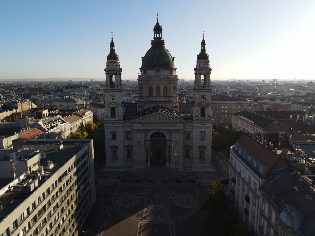
Hungarian Parliament: the ultimate riverbank subject
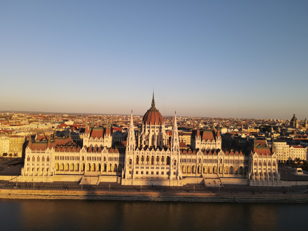
The Hungarian Parliament Building is a drone filmmaker’s dream: it reads clearly even at distance, has strong symmetry, and sits directly on the Danube’s edge, which makes it exceptionally easy to compose with foreground reflections and bridge lines. It’s a Neo-Gothic landmark designed by Imre Steindl and opened in 1902, and it remains the single most visually dominant civic structure on the Pest bank.
Aerial advantage:
Its repeated vertical elements (spires + facade rhythm) stay sharp in wide shots, and the dome remains a “center lock” for orbiting moves.
Aerial challenge:
Because it’s such a famous focal point, you’re rarely alone—other drones, tourist boats, changing light, and heavy restrictions in central areas all increase operational complexity (more on that below).
Bridges as “frames inside the frame”
Budapest’s bridges don’t just connect the banks—they function as architectural composition tools in aerial footage. Their geometry creates:
-
leading lines into the city core
-
layered depth through trusses, pylons, and cables
-
perfect parallax when flying laterally along the river
The Chain Bridge, one of the most iconic elements in those river sequences, has been heavily discussed in recent years due to major renovation and traffic changes.
Aerial advantage:
Bridges give you speed, structure, and scale in one shot—especially when aligned with the Parliament, Castle Hill, or long river corridors.
Aerial challenge:
Bridges also attract dense pedestrian and vehicle movement, which can limit safe filming opportunities and reduce “clean” takes.
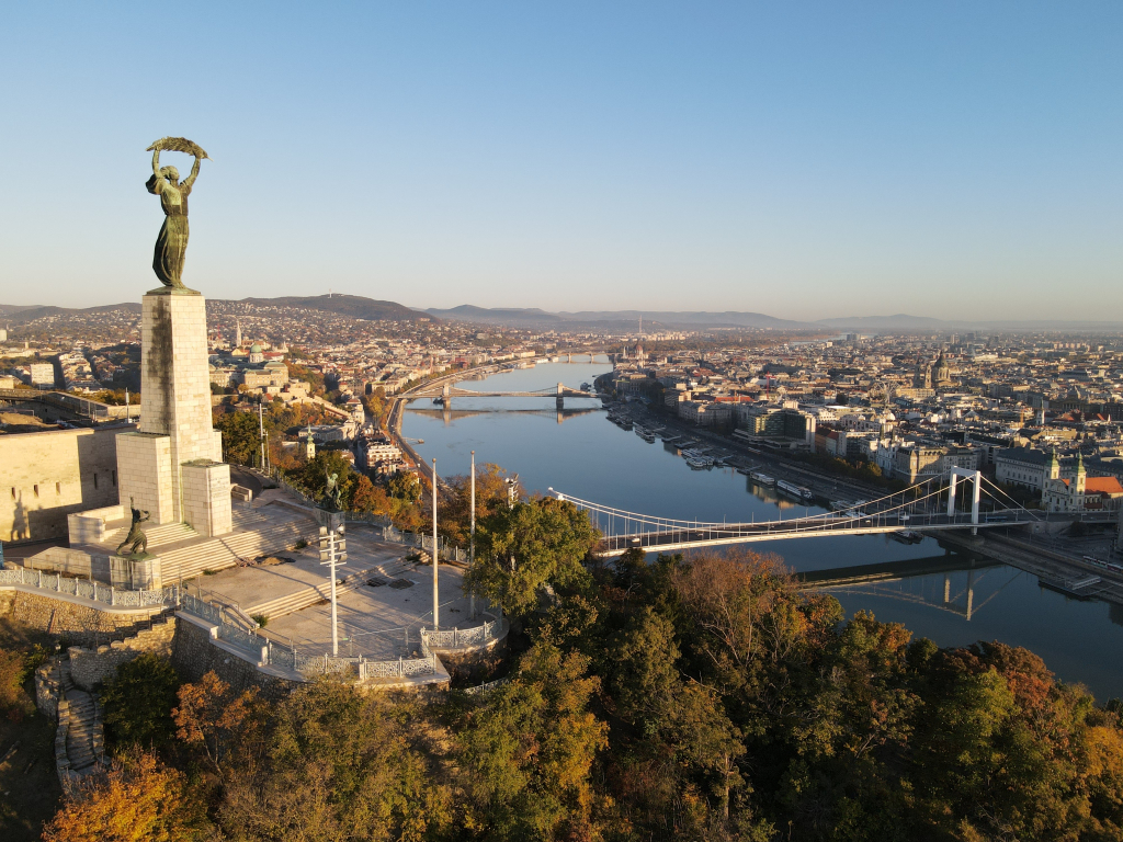
Castle Hill: the vertical counterweight to Pest
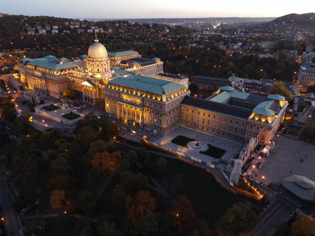
Budapest’s core cinematic tension is flat Pest vs elevated Buda. The Buda Castle Quarter is part of the UNESCO-listed landscape, and from above it delivers depth and elevation that Pest simply cannot.
What the drone sees here is urban stratification:
-
river level → embankments → rooftops → hill plateau → skyline horizon
That topographic separation is what makes Budapest feel “two-layered” on camera.
The new-old visual layer: restoration that changes aerial realism
An additional twist (especially noticeable from the air) is how parts of the Castle District have been undergoing major reconstruction work through projects like the National Hauszmann Programme, rebuilding historic forms with a noticeably “new” surface finish. That creates a unique drone problem: some shots look historically authentic, others look like hyper-polished replicas depending on angle and light.
For aerial cinematography, it becomes a question of visual continuity: do you frame for heritage texture, or for the “rebuilt” polish?
Budapest Competes With Itself: Multiple “Main Characters” in One Skyline
Most cities have one hero landmark. Budapest has several, and they fight for attention in every wide shot:
-
Parliament dominates the Pest bank
-
Castle Hill dominates the Buda silhouette
-
Bridges punctuate the river rhythm
-
The Danube ties everything into a single navigable composition
This is why Budapest “wins” as a drone city: you can fly a short segment and still capture multiple world-class subjectsin the same frame.
But it’s also why it’s difficult:
Every direction contains a better shot, so you must commit to a plan or you’ll waste batteries chasing “one more angle.”
The Drone Pilot’s Challenges in Budapest (Technical + Practical)
1) Airspace limitations and altitude constraints
Budapest is complex airspace. Official Hungarian aviation guidance notes that within the Budapest CTR, outside designated no-drone areas, unmanned aircraft may be operated up to 40 m AGL without permission from the appropriate ATS unit.
(Important: this does not override other restrictions—always verify the current map and permissions before any flight.)
This matters for filming because Budapest’s best shots often want altitude—but the operational reality can force you into a lower, more constrained perspective, especially in the central zones.
2) The “perfect subject” is often the most restricted subject
The riverbanks, Castle Hill, and Parliament area are exactly what everyone wants—so they are the first zones to carry restrictions or procedural hurdles. Even travel-oriented drone law summaries emphasize extensive restrictions across central Budapest areas and recommend appropriate authorizations for sensitive locations.
Translation for filmmakers: your most cinematic ideas can be the hardest to execute legally and safely.
3) Wind behavior: Danube corridor turbulence
In practice, large rivers and open embankments create wind corridors. Budapest can go from stable hover to micro-gust corrections fast—especially when transitioning between open river space and dense urban blocks.
Aerial impact:
-
more gimbal corrections
-
reduced smoothness on lateral moves
-
higher risk of “micro-jitter” in detailed architecture shots
4) Exposure and dynamic range: reflective water + bright stone
Budapest’s palette is a challenge for sensors:
-
bright stone and rooftops
-
deep shadows in narrow streets
-
reflective Danube highlights
To keep architectural details clean in 4K, you’re managing:
-
highlight retention on sunlit facades
-
shadow readability in dense textures
-
avoiding blown reflections on the river surface
5) Urban RF noise and precision flying
Central European capitals can be unforgiving on signal quality. Even with good link stability, dense areas demand:
-
conservative positioning
-
planned line-of-sight
-
minimal “creative improvisation” near obstacles
Budapest’s architecture rewards close composition—but it punishes careless proximity.
What Makes Budapest a “Top-Tier Drone City” for Architecture Films
A city becomes elite for drone filming when it offers continuous architectural variety without needing constant relocation. Budapest delivers:
-
monumental civic architecture on the waterline
-
heritage elevation and skyline layering
-
bridges that function as compositional devices
-
an urban structure that reads clearly from above
And that is why Budapest doesn’t just look good from above—it performs well on camera.
Film Summary: Aerial Architecture First, Everything Else Secondary
This film was built around one rule:
Prioritize architecture as geometry.
Not tourism. Not fast cuts. Not “highlights.”
Just the city’s structure from above—clean lines, landmark hierarchy, and the challenge of capturing an urban masterpiece under real operational constraints.
If you want to publish this as a web article, here are high-value SEO phrases you can reuse naturally:
Budapest drone video 4K, Budapest aerial architecture, Budapest from above, Danube drone footage, Hungarian Parliament drone, Buda Castle aerial, Budapest cinematic drone film.
Year
2022
Director
Gamaal El Attar